111874-01
Tabulae motuum solis et lunae novae et correctae.
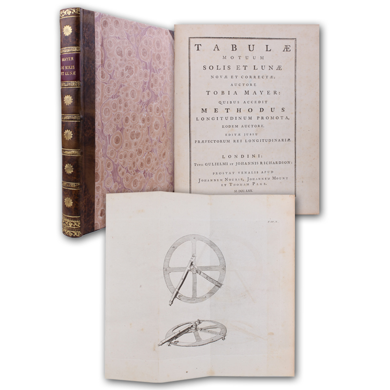
London, Richardson u.a. 1770. - (27 x 21,5 cm). VII, 136 (2) CXXX (1) S., 1 Bl. Anzeigen. Mit 2 gefalteten Kupfertafeln. Dekorativer moderner Halblederband im Stil der Zeit mit hübscher Rückenvergoldung.
Einzige Ausgabe, herausgegeben von Neville Maskelyne. - In 1752 the cartographer and astronomer Mayer (1723-1762) "drew up new lunar and solar tables calculated to the unprecedented accuracy of ± 1', a revolutionary improvement that enabled the moon's celestial position on any standard meridian at any given time to be predicted within just over a degree. Mayer submitted a manuscript copy of these tables in 1755 to the Lords Commissioners of the British Admiralty, hoping to receive the prize guaranteed by the Act of Parliament... to 'such person... as shall discover the longitude at sea'; meanwhile, he continued to improve the tables until his death in 1762. In 1763 Mayer's widow sent a copy of the... tables to the Board of Longitude, which deemed them of great use in the lunar-distance method of finding the longitude at sea and awarded Mayer's widow a prize of Ł 3,000. The tables were edited... by Nevil Maskelyne, the Astronomer Royal, who used them to compute the lunar and solar ephemerides in the early editions of his 'Nautical almanac'" (Norman). Mayers "Methode des Monddistanzenverfahrens setzte sich neben dem Seechronometer von J. Harrison für die Längenbestimmung auf See durch und bestimmte die Schiffahrtspraxis bis zur Mitte des 19. Jh." (NDB 16, 529). - Vereinzelt minimal stockfleckig bzw. gebräunt. Zwei Blätter jeweils mit hinterlegtem Einriss, sonst schönes und wohlerhaltenes Exemplar. - DSB 9, 233; Poggendorff II, 92; Norman 1468
Tabulae motuum solis et lunae novae et correctae.
London, Richardson u.a. 1770. - (27 x 21,5 cm). VII, 136 (2) CXXX (1) S., 1 Bl. Anzeigen. Mit 2 gefalteten Kupfertafeln. Dekorativer moderner Halblederband im Stil der Zeit mit hübscher Rückenvergoldung.
Einzige Ausgabe, herausgegeben von Neville Maskelyne. - In 1752 the cartographer and astronomer Mayer (1723-1762) "drew up new lunar and solar tables calculated to the unprecedented accuracy of ± 1', a revolutionary improvement that enabled the moon's celestial position on any standard meridian at any given time to be predicted within just over a degree. Mayer submitted a manuscript copy of these tables in 1755 to the Lords Commissioners of the British Admiralty, hoping to receive the prize guaranteed by the Act of Parliament... to 'such person... as shall discover the longitude at sea'; meanwhile, he continued to improve the tables until his death in 1762. In 1763 Mayer's widow sent a copy of the... tables to the Board of Longitude, which deemed them of great use in the lunar-distance method of finding the longitude at sea and awarded Mayer's widow a prize of Ł 3,000. The tables were edited... by Nevil Maskelyne, the Astronomer Royal, who used them to compute the lunar and solar ephemerides in the early editions of his 'Nautical almanac'" (Norman). Mayers "Methode des Monddistanzenverfahrens setzte sich neben dem Seechronometer von J. Harrison für die Längenbestimmung auf See durch und bestimmte die Schiffahrtspraxis bis zur Mitte des 19. Jh." (NDB 16, 529). - Vereinzelt minimal stockfleckig bzw. gebräunt. Zwei Blätter jeweils mit hinterlegtem Einriss, sonst schönes und wohlerhaltenes Exemplar. - DSB 9, 233; Poggendorff II, 92; Norman 1468
4.800 €